微信小程序:位置API
目录
API介绍
首先我们看一下wx.getLocation函数
https://developers.weixin.qq.com/miniprogram/dev/api/location/wx.getLocation.html
作用
作用:获取当前的地理位置、速度。当用户离开小程序后,此接口无法调用。
开启高精度定位,接口耗时会增加,可指定 highAccuracyExpireTime 作为超时时间。地图相关使用的坐标格式应为 gcj02。高频率调用会导致耗电,如有需要可使用持续定位接口 wx.onLocationChange。基础库 2.17.0 版本起 wx.getLocation 增加调用频率限制
参数
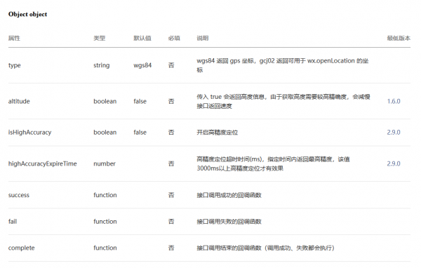
Object object
gps:美国
gcj02:中国
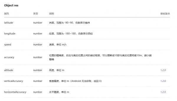
object.success 回调函数
前置准备
登录
若想调用位置API,需要首先在创建app实例的时候调用登录接口: wx.login
. app.js:
// app.js
App({
  onLaunch() {
    // 展示本地存储能力
    const logs = wx.getStorageSync('logs') || []
    logs.unshift(Date.now())
    wx.setStorageSync('logs', logs)

    // 登录
    wx.login({
      success: res => {
        // 发送 res.code 到后台换取 openId, sessionKey, unionId
      }
    })
  },
  globalData: {
    userInfo: null
  }
})
简单测试
data
index.js:
  data: {
    latitude: 0,
    longitude: 0,
    speed:0,
    accuracy:0

}
js
index.js:
注意:这里的var that = this 以及回调函数里的that.setData
回调函数中的this 和回调函数以外的this 不是一回事,所以这里用了一个that
  geoInfo() {
    var that = this
    wx.getLocation({
      type: 'gcj02',
      scale:18,
      success(res) {

        that.setData({
          latitude: res.latitude,
          longitude: res.longitude,
          speed: res.speed,
          accuracy: res.accuracy,
        })
      }
    })
    console.log(this.data.latitude, this.data.longitude)
  },
WXML
<view class='top'>
  <button bindtap='geoInfo'>位置</button>
</view>
WXSS
button{
  margin:20rpx;
}
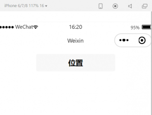
效果图
点击开发者工具的‘真机调试'
手机上点击小程序的‘位置’按钮,
显示:
0 0
VM21:2 exparser SCL backend initialized
index.js:43 0 0
index.js:43 36.69251736111111 117.01947916666667
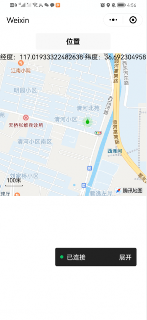
位置API与地图结合
地图map组件
https://developers.weixin.qq.com/miniprogram/dev/component/map.html
wxml代码
<view class='top'>
  <button bindtap='geoInfo'>位置</button>
</view>
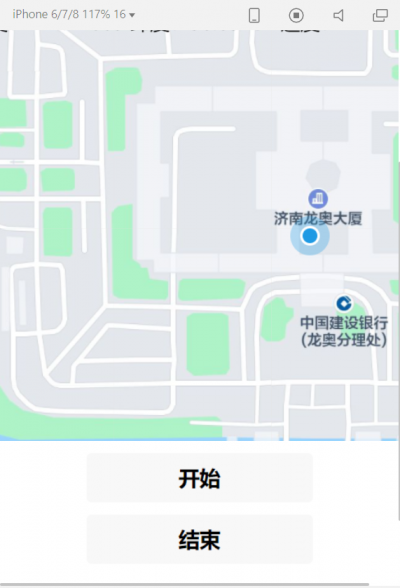
<map id='myMap' style="width:100%; height:350px" longitude='{{longitude}}' latitude='{{latitude}}' markers='{{markers}}'  show-location >
  <view class='cover'>
    经度:{{longitude}} 纬度:{{latitude}} 速度:{{speed}}
  </view>
</map>
showlocation:显示带有方向的当前定位点
授权
https://developers.weixin.qq.com/miniprogram/dev/framework/open-ability/authorize.html
部分接口需要经过用户授权同意才能调用。我们把这些接口按使用范围分成多个 scope ,用户选择对 scope 来进行授权,当授权给一个 scope 之后,其对应的所有接口都可以直接使用。
此类接口调用时:
- 如果用户未接受或拒绝过此权限,会弹窗询问用户,用户点击同意后方可调用接口;
- 如果用户已授权,可以直接调用接口;
- 如果用户已拒绝授权,则不会出现弹窗,而是直接进入接口 fail 回调。请开发者兼容用户拒绝授权的场景
授权的全局设置
https://developers.weixin.qq.com/miniprogram/dev/reference/configuration/app.html
app.json:
  "permission": {
    "scope.userLocation": {
      "desc": "你的位置信息将用于小程序位置接口的效果展示"
    }
  }
地图提示鉴权失败:2.12.2基础库以后就出现问题,会提示鉴权失败,基础库调到2.12.1之前就不会出现这个问题,能够正常使用
动态获得位置
wxml
添加如下代码:
<button bindtap='startRun'>开始</button>
<button bindtap='stopRun'>结束</button>
data
data{
    ...
    begin_la: 0,
    begin_lo: 0,
    ...
}
js
定时器: https://developers.weixin.qq.com/miniprogram/dev/reference/api/setInterval.html
  startRun(){
    this.geoInfo()
    this.data.begin_la=this.data.latitude
    this.data.begin_lo = this.data. longitude
},
 stopRun(){
  this.geoInfo()
  console.log('开始位置', this.data.begin_la, this.data.begin_lo)
  console.log('结束位置', this.data.latitude, this.data.longitude)
  console.log(this.data)
 },
 running() {
  this.data.latitude += 0.0002
  this.data.longitude += 0.0002
},

  /**
   * 生命周期函数--监听页面加载
   */
  onLoad: function (options) {

  },

  /**
   * 生命周期函数--监听页面初次渲染完成
   */
  onReady: function () {
    var interval = setInterval(O=>{this.running()
    },1000)

  },
控制台输出:
开始位置 36.654239999999994 117.12249000000008
index.js? [sm]:53 结束位置 36.65483999999999 117.1230900000001
index.js? [sm]:54 {demo_la: 48.1545, demo_lo: 82.3555907, latitude: 36.65483999999999, longitude: 117.1230900000001, begin_la: 36.654239999999994, …}
代码示例
index.js
Page({

  /**
   * 页面的初始数据
   */
  data: {
    demo_la: 48.1545,
    demo_lo: 82.3555907,
    latitude: 0,
    longitude: 0,
    begin_la: 0,
    begin_lo: 0,
    interval: 0,
    speed: 0,
    accuracy: 0,
    markers: [{
      iconPath: "../../imgs/pic.jpg",
      id: 0,
      latitude: 39.9205,
      longitude: 116.4605,
      width: 30,
      height: 30
    }]

  },
  openLoc() {
    this.mapCtx.includePoints({
      padding: [10],
      points: [{
        latitude: 23.10229,
        longitude: 113.3345211,
      }, {
        latitude: 23.00229,
        longitude: 113.3345211,
      }]
    })
  },

  geoInfo() {
    var that = this
    wx.getLocation({
      type: 'gcj02',
      scale:18,
      success(res) {

        that.setData({
          latitude: res.latitude,
          longitude: res.longitude,
          speed: res.speed,
          accuracy: res.accuracy,
        })
      }
    })
    console.log(this.data.latitude, this.data.longitude)
  },

  startRun() {
    var that = this
    clearInterval(this.data.interval)

    wx.getLocation({
      type: 'gcj02',
      success(res) {
        var la = res.latitude
        var lo = res.longitude
        that.setData({
          begin_la: la,
          begin_lo: lo,
          'markers[1]': {
            iconPath: "../../imgs/red.png",
            id: 1,
            latitude: la,
            longitude: lo,
            width: 20,
            height: 20
          }
        })
      }
    })

    var interval = setInterval(() => {
      this.running()
    }, 1000)


  },
  stopRun() {
    var that = this
    clearInterval(this.data.interval)
    wx.getLocation({
      type: 'gcj02',
      success(res) {
        var la = res.latitude
        var lo = res.longitude
        that.setData({
          latitude: la,
          longitude: lo,
          'markers[2]': {
            iconPath: "../../imgs/yellow.png",
            id: 2,
            latitude: la,
            longitude: lo,
            width: 20,
            height: 20
          }
        })
      }
    })
    console.log('开始位置', this.data.begin_la, this.data.begin_lo)
    console.log('结束位置', this.data.latitude, this.data.longitude)
    console.log(this.data)
  },
  running() {
    this.data.latitude += 0.0002
    this.data.longitude += 0.0002
  },
  center() {
    this.mapCtx.getCenterLocation({
      success: function (res) {
        console.log(res.latitude,res.longitude)
      }
    })

  },
  trans() {
    this.mapCtx.translateMarker({
      markerId: 0,
      autoRotate: false,
      duration: 3000,
      destination: {
        latitude: 40.30229,
        longitude: 116.7545211,
      },
      animationEnd() {
        console.log('animation end')
      }
    })
  },
  onReady: function () {
    this.mapCtx = wx.createMapContext('myMap')
  },
})
//index.wxml <view class='top'>
 <button bindtap='geoInfo'>位置</button>
 <button bindtap='openLoc'>打开</button>
 <button bindtap='center'>定心</button>
 <button bindtap='trans'>动</button>
</view>
index.wxml:
<map id='myMap' style="width:100%; height:350px" longitude='{{longitude}}' latitude='{{latitude}}' markers='{{markers}}' polyline="{{polyline}}" show-location subkey='IWLBZ-CK6R4-YXDUO-DQCXK-J5H4Z-DSBCI'>
  <cover-view calss='cover'>
    经度:{{longitude}} 纬度:{{latitude}} 速度:{{speed}}
  </cover-view>
</map>

<button bindtap='startRun'>开始</button>
<button bindtap='stopRun'>结束</button>
.
